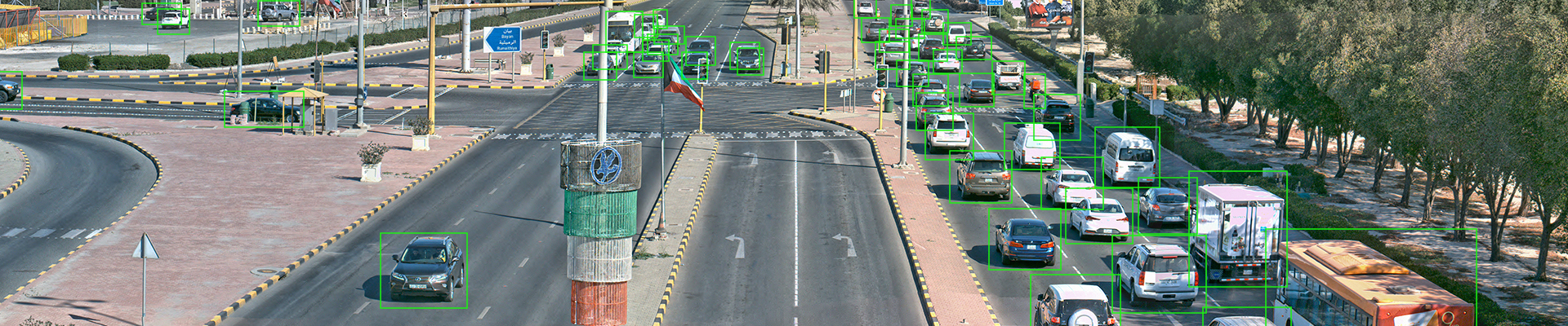
Highway surveillance is complex due to the expansive and dynamic nature of roads, therefore it requires advanced solutions. Traffic violation detection, accident prevention and incident management are crucial tasks where traditional surveillance often falls short. Highways present challenges in establishing extensive surveillance networks due to their sheer size. Varying lighting conditions hinder visibility, complicating real-time monitoring and incident detection. Responding quickly to incidents on highways is difficult for traditional systems that lack real-time analysis and automated detection. Manual monitoring is inefficient and labor-intensive, leading to blind spots and delayed incident reporting.
The Solution
The Logipix Highway Surveillance Solution addresses these challenges comprehensively. Its high-resolution panoramic cameras cover extensive sections efficiently, allowing automatic object tracking and motion behavior analysis. This enables swift response times, guiding patrol units and law enforcement in emergency situations. Advanced technologies, like wide dynamic range sensors and edge AI gather precise information, even in low-light or adverse conditions. Logipix’s system aids in real-time decision-making, facilitates remote operations, and offers detailed evidence for incident investigations. By providing automatic patrol tours and comprehensive traffic violation detection, it enables effective traffic surveillance.
» Key focus
HIGS revolutionizes highway surveillance with high-resolution Panorama Cameras, edge AI and 3D radar technologies. It accelerates emergency responses, aids highway patrols and supports police work.
■ The solution offers purpose-designed panoramic cameras ranging from 100 MP to 320 MP resolution, allowing extensive coverage with single devices, thereby reducing the number of necessary cameras for full coverage along lengthy highway sections.
■ The solution provides advanced Sensor Fusion Technology, combining AI-powered Video Content Analysis and Radar Data Analysis, enabling automatic alerts for various types of suspicious or unsafe road behavior.
■ The system accurately tracks each detected objects, records their statuses, simplifies real-time object searches, and facilitates the retrieval of captured violations in historical mode.
■ HIGS offers remote manual and automatic patrol tours along the covered highway sections using predefined and optional zoom positions on the high-resolution panoramic images.
» AI-Powered Highway Surveillance
Our high-end Panorama Cameras, equipped with edge AI, have the capability to detect and alert authorities to numerous suspicious activities. They provide evidence of traffic violations or accidents, as well as aid in managing traffic flow and reducing congestion.
Road Safety | Violation Detection
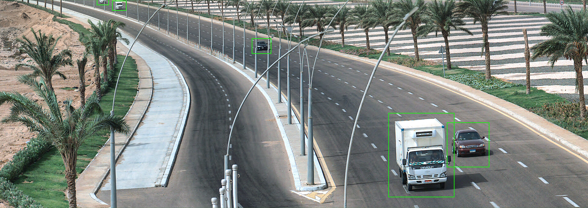
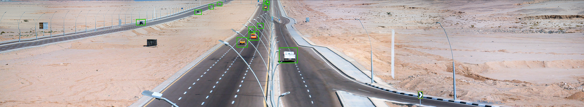
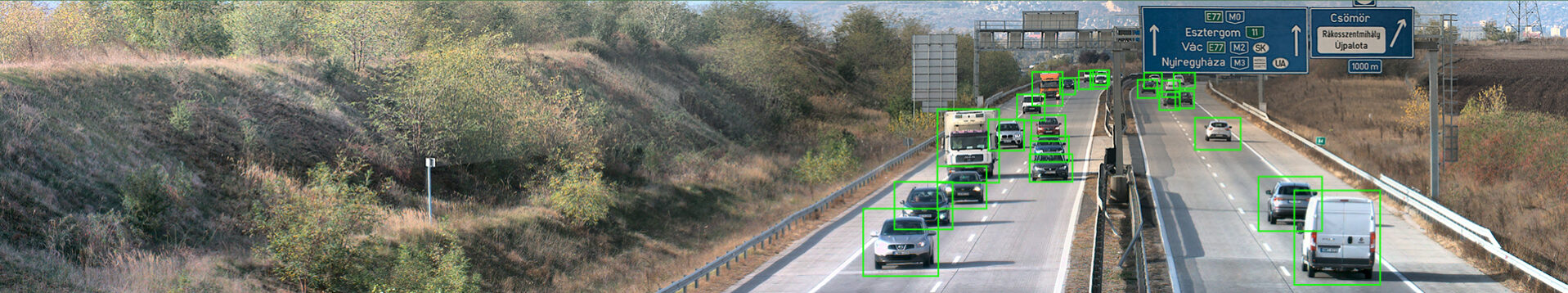
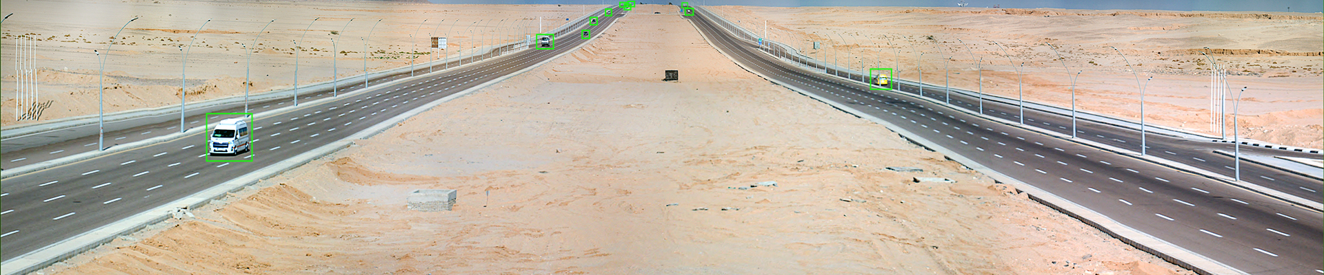
The Logipix Panorama cameras are able to detect a wide range of unsafe activities on highways, from too slow or too fast vehicles to lane violations, wrong-way driving, and off-road driving. The system is able to track and alert authorities to these activities in real-time, allowing for a faster response time and more effective law enforcement.
Remote Highway Operations
Through its advanced monitoring and analysis capabilities, HIGS detects and promptly notifies authorities of obstructions on roadways, traffic congestion points, and unforeseen incidents such as collisions. Real-time detection aids in swift response, ensuring prompt intervention to clear obstructions, ease traffic flow, and expedite emergency assistance when accidents occur.
Fast & Irrefutable Evidence
The Logipix Highway Surveillance Solution offers rapid archive searches through an in-memory object history database. This feature enables users to search for specific incidents and object types within designated time frames and areas. To effectively navigate this extensive database, multi-level filtering functions are available.
» Virtual Patrol Tours
The virtual patrol tour function enables remote and automated highway patrol tours in both live and historical operation modes. It minimizes the need for constant physical presence on highways.
Live Patrol Tour
The function allows operators to remotely monitor road conditions and manage highway patrol duties using the live video streams of the 100-320 MP Panorama Cameras. This virtual patrol tour allows operators to move virtually among predefined zoom positions, just like they would be moving in a street view application.
Interactive Map
The front-end interface offers an abstract interactive map, where operators can freely navigate among predefined or optional positions, corresponding to specific zoom positions on the camera images. This map includes multiple clearly identifiable reference points for fast orientation. Vehicle and other object positions are localized in relation to these reference points.
Historical Patrol Tour
The historical patrol tour offers invaluable benefits in analyzing past incidents and enhancing future operational strategies. By accessing historical data and playback features from contiguous panoramic video streams, operators gain a comprehensive understanding of previous events, enabling accurate post-incident analysis.
» Benefits of using HIGS
Financial Benefits
■ Reducing the Cost of Highway Patrols – HIGS provides specially developed remote patrol control functions for extensive highway sections, utilizing high-resolution images from Panorama cameras. ■ Operation with Fewer Personnel – Fewer operators are required to manage the highway surveillance system, and fewer patrol units are necessary for physical presence on the roads. ■ Preventive Road Maintenance Savings – Monitoring infrastructure conditions can help in identifying maintenance needs before they become critical, reducing repair costs and prolonging the lifespan of highway assets. ■ Minimized Human-Related Maintenance – HIGS hardware components have self-maintenance features such as integrated self-cleaning and deicing systems, minimizing the requirement for frequent human involvement. ■ Remote System Health Monitoring – Remote monitoring modules streamline maintenance processes, reducing costs and saving time. By receiving early warnings, operators can swiftly identify and resolve issues, eliminating downtime.
Future-proof Technologies for Enduring Investment
Our engineers have developed leading-edge technologies ensuring long-term system durability, avoiding physical and technological obsolescence..
Operational Benefits
■ Enhanced visibility – HIGS provides high-resolution visual coverage of extensive highway sections and their surrounding areas using only a few high-end Panorama Cameras. ■ Virtual Patrol Tours – Highway patrol tours can be conducted remotely and even automatically, navigating virtually among preset zoom positions, resembling the functionality of street view applications. ■ Increased Situational Awareness – HIGS helps operators to make informed decisions and effectively respond emergencies. Its integrated features, including advanced alert functions and seamless coordination interfaces, ensure quick responses in managing highway incidents and operations. ■ Real-Time Decision-Making Support – The Logipix Highway Surveillance Solution consistently highlights the most critical situations on the display, guiding the focus of operators. ■ Reliable Visual Evidence – HIGS provides detailed investigative capabilities, offering indisputable visual evidence in ambiguous situations like accidents and criminal incidents.
» RESISTANT HARDWARE COMPONENTS
The Panorama Cameras of the HIGS are engineered to endure even the harshest environmental conditions, proving their resilience against extreme cold, heat, humidity and desert environments.
■ Cameras and NVRs are rugged, full metal constructions
■ Designed for long-term-use
■ Special outdoor, weather- and vandal-proof design
■ Built-in heat pipes and heat sinks with fans
■ Glass heating and zone divided, contact-based house heating
» Features & Functions
Object Tracking
HIGS automatically registers and tracks objects precisely within the entire monitored area, regardless of whether they move from one camera image to another. It offers accurate positioning by fusing raw data from Video Content Analysis and Radar Data Analysis.
Classification
The system classifies diverse objects with high precision. Operators can utilize this function to filter for heavy and light vehicles, humans and animals. The system alerts operators in case of animal presence in the highway area.
Interactive Map
The solution provides an interactive map interface for seamless navigation through various zoom presets. An overview map facilitates navigation on a larger scale, while a detailed, zoomable map aids in navigating smaller-scale road sections more efficiently.
Virtual Patrol Tours
Operators can start remote patrol tours virtually navigating within panoramic images, similar to using a street view application.
Geolocalization
The system offers accurate positioning of tracked objects throughout the entire monitored area by fusing raw data from Video Content Analysis and Radar Data Analysis.
Incident Detection
Utilizing Object Feature Extraction, Motion Behavior Analysis and Motion Path Estimation algorithms, HIGS is able to detect various incidents including unsafe driving, road obstructions, and unforeseen events like accidents.
Traffic Counting
HIGS offers AI-powered, image-based traffic counting. This feature significantly reduces the expenses associated with automatic traffic counting, as it operates without the necessity of integrating expensive physical induction loops.
Object History
Rather than a simple time-based archive search, HIGS introduces a sophisticated object-based search module. This feature facilitates the identification and retrieval of suspicious situations.
User Statistics
The activities of operators within the system can be continuously monitored and tracked for assessment and oversight.
» System Architecture
» Learn more
Drive into the future with Logipix Highway Surveillance. Experience cutting-edge AI technology & panoramic cameras developed to revolutionize highway monitoring. Download our latest HIGS brochure now for details.
Discover the power of HIGS – our cutting-edge highway surveillance solution. Download our latest leaflet to delve into the essence of HIGS and unlock its full potential for ensuring road safety and security.
Download our latest Company Profile brochure for exclusive insights into cutting-edge solutions revolutionizing video monitoring and surveillance. Stay ahead with Logipix.
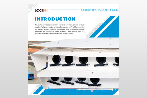
This booklet offers a comprehensive overview of our various panorama concepts. You will gain exclusive insights into the hardware units, edge AI, and advanced display technology. These components collectively form a complete solution that shape the future of video surveillance.
The Logipix Panorama camera produces hundreds of megapixel images with details that provides effective visual information in all lighting conditions.
The camera delivers wide dynamic range, has improved low-light performance and extra high sensitivity.
Main products
Logipix 320 MP 40° Visible Panorama
The Logipix 320 MP Panorama camera camera provides wide dynamic range images, have an improved low-light performance and extra high sensitivity.
The camera house is completed with an automatic self-cleaning system that consists of a tank with cleaning liquid, a dispenser system and wipers at every window for the best images.
Main products
Logipix 300 MP 180° Visible Panorama
The Logipix 300 MP Panorama camera camera provides wide dynamic range images, have an improved low-light performance and extra high sensitivity.
The camera house is completed with an automatic self-cleaning system that consists of a tank with cleaning liquid, a dispenser system and wipers at every window for the best images.
Main products
Logipix 200 MP 180° Visible Panorama
The Logipix 200 Mp Panorama camera images ensure an expanded view. Operators can continuously observe the whole monitored area on one camera image without redundant or hidden areas. The huge resolution even makes it possible to recognize faces at a large distance. The camera house is completed with an automatic self-cleaning system that consists of a tank with cleaning liquid, a dispenser system and wipers at every window for the best images.
Main products
Logipix 960 MP 120° Visible Panorama
The Logipix 960 MP Panorama camera images ensure an expanded view. Operators can continuously observe the whole monitored area on one camera image without redundant or hidden areas.
The huge resolution even makes it possible to recognize faces at a large distance.
Main products
Logipix 120 MP 120° Visible Dronw Panorama
This military grade camera provides expanded vision for unmanned aircraft systems. Equipping the drone with a 120 MP Drone Panorama Camera provides continuous 120° monitoring over the surroundings.
The rugged camera housing contains a 120 MP multi-sensor panorama camera for high-resolution visible light imaging.
Main products
Logipix 20 MP Visible Camera
The Logipix ONE 20 MP camera produces a 20 FPS video stream at full resolution, therefore any motion in the footage seems continuous. The device uses the visually lossless JPEG2000 wavelet-based compression method, compressing each frame separately. The video stream does not contain predicted frames.
Main products
Logipix 20 MP Visible Bullet Camera
The 20 Megapixel Day/Night Camera is encased in a rugged IP66 housing, designed to withstand vibration in accordance with MIL STD 810G. It provides high-performance images, even in extreme environmental conditions, in temperatures ranging from -40°C to +70°C.
Main products
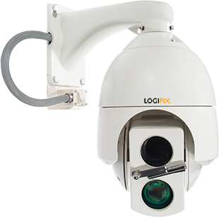
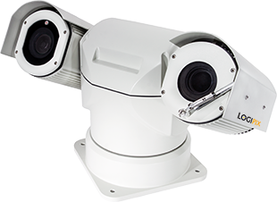
Logipix 6 MP PTZ Camera
The PTZ has a unique integrated Laser illuminator with an automatic cooperating focus system, it is able to provide quality images of monitored targets even in low lighting conditions.
Main products
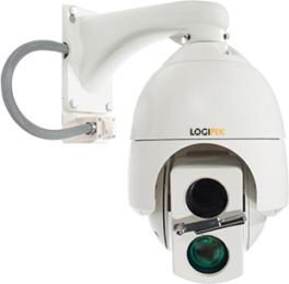
Logipix 2 MP Long-Range PTZ Camera
The Logipix 2 MP PTZ ensures a high resolution and a 25 FPS speed. The camera provides effective manual target tracking thanks to its fast positioning and high accuracy within a 360° horizontal and 180° vertical range.
The PTZ has a unique integrated IR Laser illuminator with an automatic cooperating focus system.
Main products
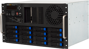
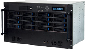
Logipix Gen4 Network Video Recorder
Logipix NVR Rack-mount is a 4th generation, high performance network video recorder specially designed for the Logipix Panorama and single cameras.
7 Gbit/sec recording speed ensures the reliable recording of the 20 FPS video streams of the Logipix ONE cameras without any reduction in camera performance.
Main products
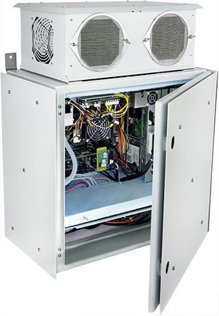
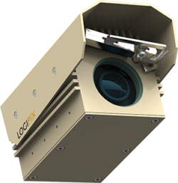
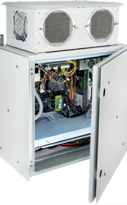
Logipix Gen4 Outdoor NVR
The Logipix NVR Outdoor is the high speed network video recorder of the Logipix solutions that was specially developed for on-site recording tasks.
The thermal control of the electronic components relies on a combined system of integrated heat pipes and fans, a thermoelectric peltier cooler and sunshields.
Main components for our solutions
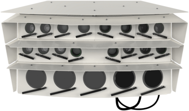
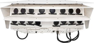
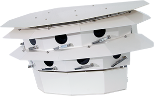
Logipix 328 MP Thermal & Visible Panorama
The Logipix Panorama camera produces hundreds of megapixel images with details that provides effective visual information in all lighting conditions.
The camera delivers wide dynamic range, has improved low-light performance and extra high sensitivity.
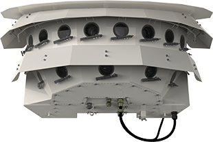
Logipix 300 MP 180° Visible Panorama
The Logipix 300 MP Panorama camera produces hundreds of megapixel large images on which every detail is clearly visible in all lighting conditions.
The camera provides wide dynamic range images, have an improved low-light performance and extra high sensitivity. This camera is able to cover large areas with high resolution from a single viewpoint.
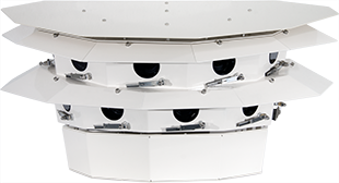
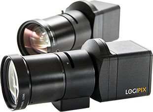
Logipix 320 MP 40° Visible Panorama
The Logipix 320 MP Panorama camera camera provides wide dynamic range images, have an improved low-light performance and extra high sensitivity.
The camera house is completed with an automatic self-cleaning system that consists of a tank with cleaning liquid, a dispenser system and wipers at every window for the best images.
Logipix 200 MP 180° Visible Panorama
The Logipix 200 MP Panorama camera images ensure an expanded view. Operators can continuously observe the whole monitored area on one camera image without redundant or hidden areas. The huge resolution even makes it possible to recognize faces at a large distance.
The camera house is completed with an automatic self-cleaning system that consists of a tank with cleaning liquid, a dispenser system and wipers at every window for the best images.
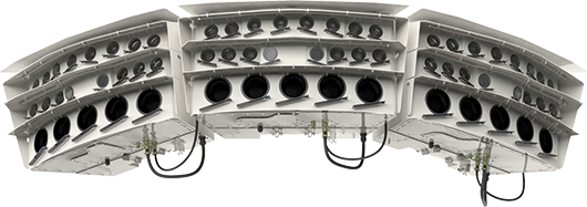
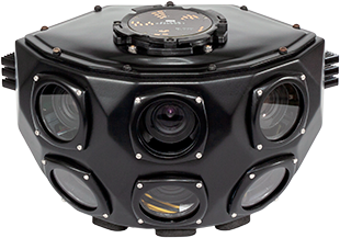
Logipix 978 MP 120° Dual-Vision Panorama
The Logipix 978 MP Thermal & Visible light Panorama camera images ensure an expanded view. Operators can continuously observe the whole monitored area on one camera image without redundant or hidden areas. The huge resolution even makes it possible to recognize faces at a large distance.
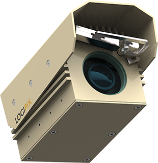
Logipix 120 MP 120° Drone Panorama
This military grade camera provides expanded vision for unmanned aircraft systems. Equipping the drone with a 120 MP Drone Panorama Camera provides continuous 120° monitoring over the surroundings.
The rugged camera housing contains a 120 MP multi-sensor panorama camera for high-resolution visible light imaging.
Logipix ONE 20 MP Visible Camera
The Logipix ONE 20 MP camera produces a 20 FPS video stream at full resolution, therefore any motion in the footage seems continuous.
The device uses the visually lossless JPEG2000 wavelet-based compression method, compressing each frame separately. The video stream does not contain predicted frames.
Logipix ONE 20 MP Bullet Camera
The 20 Megapixel Day/Night Camera is encased in a rugged IP66 housing, designed to withstand vibration in accordance with MIL STD 810G.
It provides high-performance images, even in extreme environmental conditions, in temperatures ranging from -40°C to +70°C.
Logipix 6 MP PTZ Camera
The PTZ has a unique integrated Laser illuminator with an automatic cooperating focus system, it is able to provide quality images of monitored targets even in low lighting conditions.
Specially developed PTZ control functions in the Logipix Control Center, such as mouse controlled joystick emulation, the PointIT control function or PTZ position bookmarks make monitoring convenient and easy.
Logipix 2 MP Long-Range PTZ Camera
The Logipix 2 MP PTZ ensures a high resolution and a 25 FPS speed. The camera provides effective manual target tracking thanks to its fast positioning and high accuracy within a 360° horizontal and 180° vertical range.
The PTZ has a unique integrated IR Laser illuminator with an automatic cooperating focus system.
Logipix Gen4 Network Video Recorder
Logipix NVR Rack-mount is a 4th generation, high performance network video recorder specially designed for the Logipix Panorama and single cameras.
7 Gbit/sec recording speed ensures the reliable recording of the 20 FPS video streams of the Logipix ONE cameras without any reduction in camera performance.
Logipix Gen4 Outdoor Network Video Recorder
The Logipix NVR Outdoor is the high speed network video recorder of the Logipix solutions that was specially developed for on-site recording tasks. Thanks to its massive outdoor enclosure with an IP65 rating, it is able to cope with even extreme weather conditions.
The thermal control of the electronic components relies on a combined system of integrated heat pipes and fans, a thermoelectric peltier cooler and sunshields.